Categories: Featured StoriesNews

Weather Update from the National Weather Service Office in Peachtree City, GA

Here’s an UPDATE on impact weather expected to affect north and central Georgia late tonight through Wednesday evening, as of 3:30PM EST Tuesday (November 17).

Changes from previous forecast (yesterday):
1. The heaviest rain associated with a broken “squall line” of showers/thunderstorms is expected to be about 3-6 hours slower than thought yesterday.  This will place the axis of heavy rain entering northwest GA between 12PM (noon) and 3PM Wednesday.  The heaviest rain should exit our eastern/southern-most counties after midnight, Wednesday night.

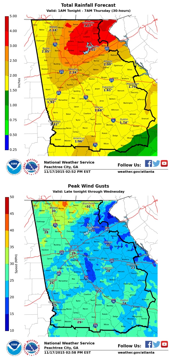
2. We are also expecting slightly higher total rainfall amounts (see attached graphic), especially across northeast Georgia where 3-4 inches of rain is possible.

Hazards (WATCHES/ADVISORIES/ETC.)

** FLOOD WATCH in effect from 10AM Wednesday through 10AM Thursday

** WIND ADVISORY in effect from 10PM Tonight through 1PM Wednesday


Primary Threats/Impacts/Timing:

  • Heavy Rain — 1 to 3 inches of rain is expected (area-wide), with locally higher amounts, between midnight tonight and early Thursday morning, with much of this rain occurring between noon (12PM) and 10PM Wednesday.
    • IMPACTS: localized flash flooding / minor flooding of area creeks/streams/rivers
  • Strong (non-thunderstorm) winds — widespread gusty winds 15-30 MPH will develop tonight, especially in the higher elevations of North GA, and continue through Wednesday.  Strongest wind gusts (> 35 MPH) are expected across exposed areas and mountain ridgetops of north Georgiabetween 12AM (midnight) and 12PM Wednesday.
    • NOTE: brief higher wind gusts (45-55 MPH) within showers and thunderstorms are possible
    • IMPACTS: downed trees/powerlines due to winds and saturated grounds from heavy rain.
  • Severe Storms — the threat for widespread severe thunderstorms continues to remain LOW – but areas along and south of a Columbus to Macon to Warrenton line may see an increased storm threat Wednesday afternoon/evening.

Confidence:

  • Heavy rain & minor flooding — High
  • Timing of heaviest rain — Medium to High
  • Strong (non-thunderstorm) winds — High
  • Downed trees due to wind + saturated soils — Medium to High

Image Attachments:

  • Total Rainfall FORECAST valid 1AM Tonight to 7AM Thursday
    • NOTE: Much of this rain is expected to occur in just a 4-8 hour window Wednesday afternoon/evening
  • Peak Wind Gusts – strongest wind gusts forecast to occur between midnight (tonight) and 3PM Wednesday

http://www.srh.noaa.gov/ffc/


Staff Writer Regional

Recent Posts

HOMEWARD BOUND PET RESCUE

HOMEWARD BOUND PET RESCUE Would you take another look at this face?  Too cute for…

3 days ago

Gilmer County Sheriffs Office Arrest Report 8/21 – 9/8/2026

Arrest report provided by the Gilmer County Sheriff’s Office requested by us. The Georgia Open…
4 days ago

Gilmer County Man Sentenced to 40 Years in Prison After Conviction on 118 Child Exploitation Counts

GILMER COUNTY, Ga. - A Gilmer County man has been sentenced to 60 years, with…

1 week ago

Gilmer Dominates Second Half, Defeats Fannin 35-14

Bobcats Take Over After Halftime, Pull Away From Rival Fannin   ELLIJAY, Ga. — For…

2 weeks ago

HOMEWARD BOUND PET RESCUE’S  PET OF WEEK

Meet Lonnie!  He is approximately  3 ½ years old and a certified “good boy”!  He…

2 weeks ago

Gilmer County Sheriffs Office Arrest Report 8/14 – 8/20/2026

Arrest report provided by the Gilmer County Sheriff’s Office requested by us. The Georgia Open…

3 weeks ago